Gila Wilderness Trip Report & Guide - Middle Fork & West Fork Loop
What follows is a very in-depth, much wordier version of the route guide I wrote for Backpacking Routes in October 2021. I wrote the following trip report first, so ideas are less concise and I spare no anecdote. Stick around if you want the full story, but head to BPR if you just want the facts. Enjoy!
A few months ago my cousin texted me asking if I would be down to do some hiking in May to celebrate his graduation from med school. I knew I had some free time in May and started researching and asking around for trails to hike in the Spring. I had never so acutely considered that May is either too hot or too snowy for hiking in a large portion of the country. I was considering the Benton MacKye Trail, Northern California, or New Mexico. I settled on Gila National Forest in New Mexico. I had heard mention of it from CDT hikers, mostly in reference to the 100+ rumored river crossings on the Gila alternate up the Middle Fork of the Gila River. A friend who lives in New Mexico named the Gila the “hidden gem of the country”, and I knew it was somewhere I had to explore.
Distance: 44.5 mile loop
Days to Complete: 3-5 days
If you’re more of a visual person, the video below will give you a feel for the Gila Wilderness.
The Middle Fork of the Gila River is a CDT alternate that most thru-hikers follow through the Gila National Forest of New Mexico. Both the Middle Fork and the West Fork of the Gila comprise a gorgeous hike through high golden canyon walls, frequent water crossings and ample opportunity for wildlife sightings. It's one of the most beautiful desert loops I've done and the easy access to water and recreation opportunities (hot springs, Gila Cave Dwellings National Monument) make for a fun, easy and fairly solitary loop. I brought my cousin who had never backpacked before and I think it is a perfect route for anyone new to backpacking (high levels of beauty and fun), or anyone more experienced who wants to have a high concentration of pretty on their hike. There are many other trails nearby so the route could be lengthened or shortened to suit preferences, but I think this particular loop is a good balance of length and scenery.

Planning
I put in minimal-to-average effort planning the trip. I ordered “Hiking New Mexico’s Gila Wilderness” and found some loops that looked neat, but I couldn’t find a detailed, comprehensive map that showed all of the trails in the area or give me any more information on mileage. I hoped that one of the outdoor stores in Silver City would have a good map that we could snag the morning of our trip, but no luck. The National Forest map covered too large of an area and didn’t include any more information on mileage than our guidebook. In the end, I downloaded some free GPX tracks on Gaia that ended up saving us a lot of hassle.
After the trip, I discovered gilatrailsinfo.org which is a much better resource than what I was trying to scramble together.
Access to Water
Hiking up the Middle Fork and down the West Fork of the Gila, you cross the river more times than you can count. Water shouldn’t be an issue when along the Gila, although the river is reporting lower than average water levels and I can’t say what will happen in coming years or in the dead of the summer.
The problem with water arises when you depart from one fork to head to another. We had planned for extra water, just in case Prior Creek was dry (it most definitely was) and were fine. Check for recent water updates here if you plan a different cut-through.
Loop Direction
Counterclockwise:
Pros: You get the majority of the river crossings out of the way in the beginning of the trip.
Cons: You’ll most likely pass both hot springs on the first day when you’ll be less likely to stop.
Clockwise:
Pros: You could potentially camp near Jordan Hot Springs on your last night. The Middle Fork eases you into water crossings. Your tired feet get a nice cool soaking from the river crossing on the last day.
Cons: The many river crossings of the Middle Fork could exacerbate foot issues if they’ve been building up to this point.
Flora and Fauna
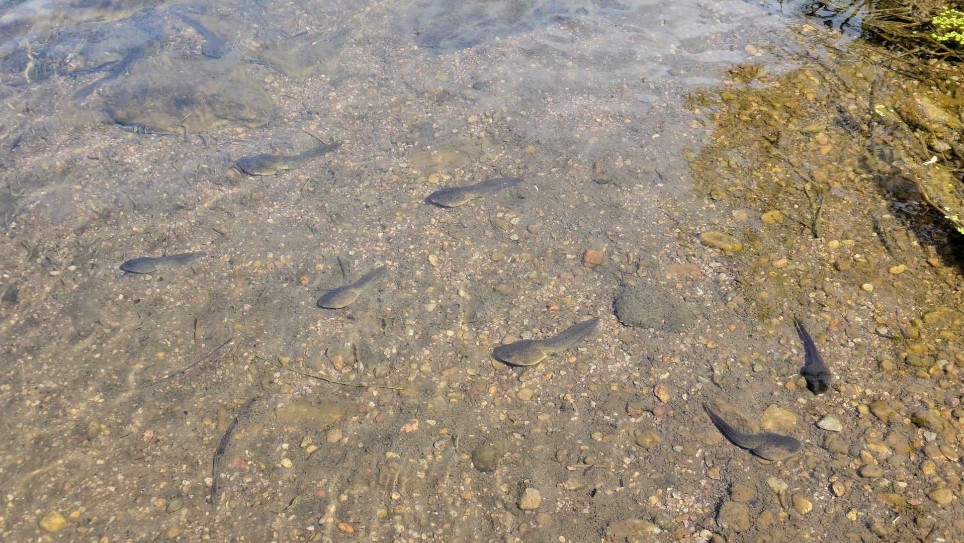
The night before our trip, we stayed at the fine establishment of a hiker friend of mine in Silver City. The Triple Crown Hostel is the place to be if you’re either hiking through the area on the CDT, biking on the GDMBR, or just driving through. Diogenes, the owner, was joking with my cousin about rattlesnakes the night before we left. Nico is not a fan and was teased about running into dozens of rattlers. On our second day, he was hiking a little bit ahead of me, heard rattling and jumped back from a small, yet mature rattlesnake in the middle of the trail. He continued rattling as I came up from behind and firmly stood his ground. The trail on either side of the snake wasn’t ideal to cut around, but we managed to give him a wide berth and went on our way. That was the only rattlesnake of the trip, but we did see a few other smaller snakes and a huge amount of tadpoles, ranging in size from a pencil eraser to an egg.
Despite the amount of greenery and beautiful wildflowers on this route, the most prominent plant to speak of was poison ivy. In most sections of trail that strayed from the riverbed, the trail was fully lined, partially lined or interspersed with this specimen. I knew how to ID poison ivy from the AT, so I spotted it fairly quickly and was incredibly careful. Sometimes slowing down to shimmy through narrow ivy-lined paths or stepping over and around the plants. My cousin was less concerned and barreled through a lot of these areas.

The trail lined with Poison Ivy.
Regardless of my avoidant efforts, on the second day of our trip I felt burning on the back of my calves and suspected the ivy devil. It had bested me. I did my best to wash my legs, but the burning only became more intense and spread around my calves and shins of both legs. I rarely hike in pants unless the weather demands it, but this is a trail I would wear pants on if and when I hike it again.
River Crossings
Hiking the Middle Fork does indeed have many river crossings. I’ve heard numbers ranging from 60-100, but I didn’t count because I didn’t want to drive myself crazy. The only thing you need to know is that there are many. Stopping every crossing to change your shoes sounds like a fantastic waste of time to me. I just plowed on through and got used to the feeling of my feet being wet. I’ve seen neoprene socks suggested, but I’m not sure how much that would actually help unless you have circulation issues.
The West Fork spends a lot more time following the river from the nearby forest and doesn’t have anywhere near as many crossings as the Middle Fork.
Trip Summary
Day 1: Middle Fork Trailhead to somewhere along the Middle Fork. Est. 13 miles or so in.
We had planned on doing the loop clockwise per the advice of Diogenes at the Triple Crown Hostel. That way we would get to camp at Jordan Hot Springs the last night and soak our tired feet in the water of the Gila during the many crossings of the Middle Fork on the way back.
Due to my lack of maps and previous knowledge about the route, I completely missed the turn for the West Fork Trailhead, which also happens to be the parking lot for Gila Cliff Dwellings National Monument.
We passed a Forest Service Visitor’s Center, which I mistakenly assumed was the National Monument and came to a trailhead that very clearly said Middle Fork Trailhead, but in my head I read it as West Fork Trailhead. It took a few miles of hiking to gain my bearings based on the terrain and landmarks while looking at the gpx tracks to realize that we were indeed on the Middle Fork. Oh well! It was already turning into an adventure and changing the plan so early on made me feel less like I had force a certain outcome. Less pressure. Pretty early on we passed a very hot and shallow hot spring, with the source spouting directly from the side of the hill next to the trail. It was too early in the day to stop and lounge, but fun to see nonetheless. Based purely on temperature, I would choose this hot spring over Jordan Hot Springs. Jordan Springs was the temperature of a bath that’s gone slightly cold. Still nice, but definitely more of a warm spring. Jordan’s appeal is in the beautiful setting which was one of the prettiest natural hot springs I’ve been to.
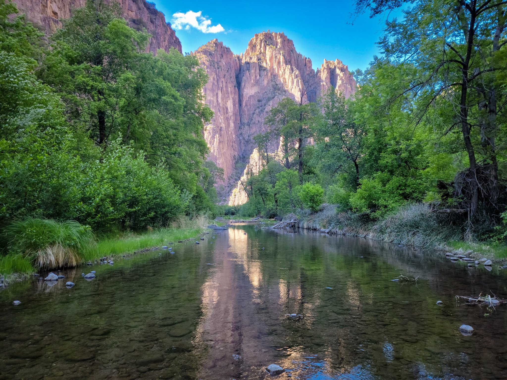
Much of the day was spent oohing and aahing over the towering canyon walls reflected in the cool water of the Gila. I stopped often to take pictures and video and found it hard to find a hiking rhythm between the gorgeous scenery demanding my attention and the frequent river crossings.
The section of trail leading up to Jordan Hot Springs was by far the busiest of the entire trip. Even though it’s over a 14 mile round trip from the trailhead, many hikers will do this as a day hike, so passing them coming and going is fairly frequent. Beyond Jordan Hot Springs, and besides the first few miles from the West Fork trailhead, other backpackers were few and far between (this may vary by season).
We spent around 20 minutes soaking in the lukewarm Jordan Springs which was also inhabited by a larger group of rowdy wine drinkers and two solo hikers. Talk circulating of the brain-eating amoeba (Nigleria Fowleri) present in the hot spring prevented us from going more than knee deep.
After this refreshing break we were back at it, our shoes soaked, but our feet refreshed. A few parties were camped at some good spots beyond the springs, but we still had about 2 hours of daylight left and wanted to keep going. The further we got, the more seldom the good campsites became and as the sun started to descend deeper beyond the canyon walls, I began to worry that we would have a less than ideal campsite. Right around sunset we found an established spot sandy enough to camp in. It wasn’t perfect, but it was a great home for the night. We quickly set up, made dinner and climbed into our tents before the sun had dropped us into the night with the sounds of the river trickling us to sleep.
Day Two
We took our time making breakfast and breaking down camp on our second day. The late start made us feel a bit frazzled and behind for the remainder of the day. We continued hiking up the Middle Fork, starting with a river crossing immediately out of camp. A larger portion of the day was spent in silence. We were tired and still getting used to the unavoidable difficulty of hiking all day long, multiple days in a row.
Around midday I felt a faint burning sensation on one of my calves. I didn’t think much of it, but coming in and out of the water crossings wasn’t helping and the sensation was spreading. It all clicked at once as I realized I had succumbed to the poison ivy I had so adamantly avoided. My cousin offered a bar of soap and I scrubbed my legs, hoping to remove all urushiol from my skin. (I’ve since learned that friction is the most important part of removing urushiol. Soap is important, but it’s the friction that really removes it. In hindsight, I wish I had used something to help scrub my legs with soap besides my hands.) I felt a bit better after I had washed my legs, but the burning sensation grew stronger as the day went on. It would temporarily be diminished by the coolness of the river crossings, but the hot sun started to make my legs throb with pain and before I knew it, the burning had spread from one calf, to the other calf, then the shin of my right leg. I figured I had done as much as I could to mitigate my discomfort and hoped the rash wouldn’t worsen. I had to get out either way, so I might as well try to enjoy it as much as I could- and not let the poison ivy get in the way.
Not gonna lie-day two felt like a slog. We were tired and took a good amount of breaks as a result. Those breaks added up and made us feel like we weren’t making a lot of progress.
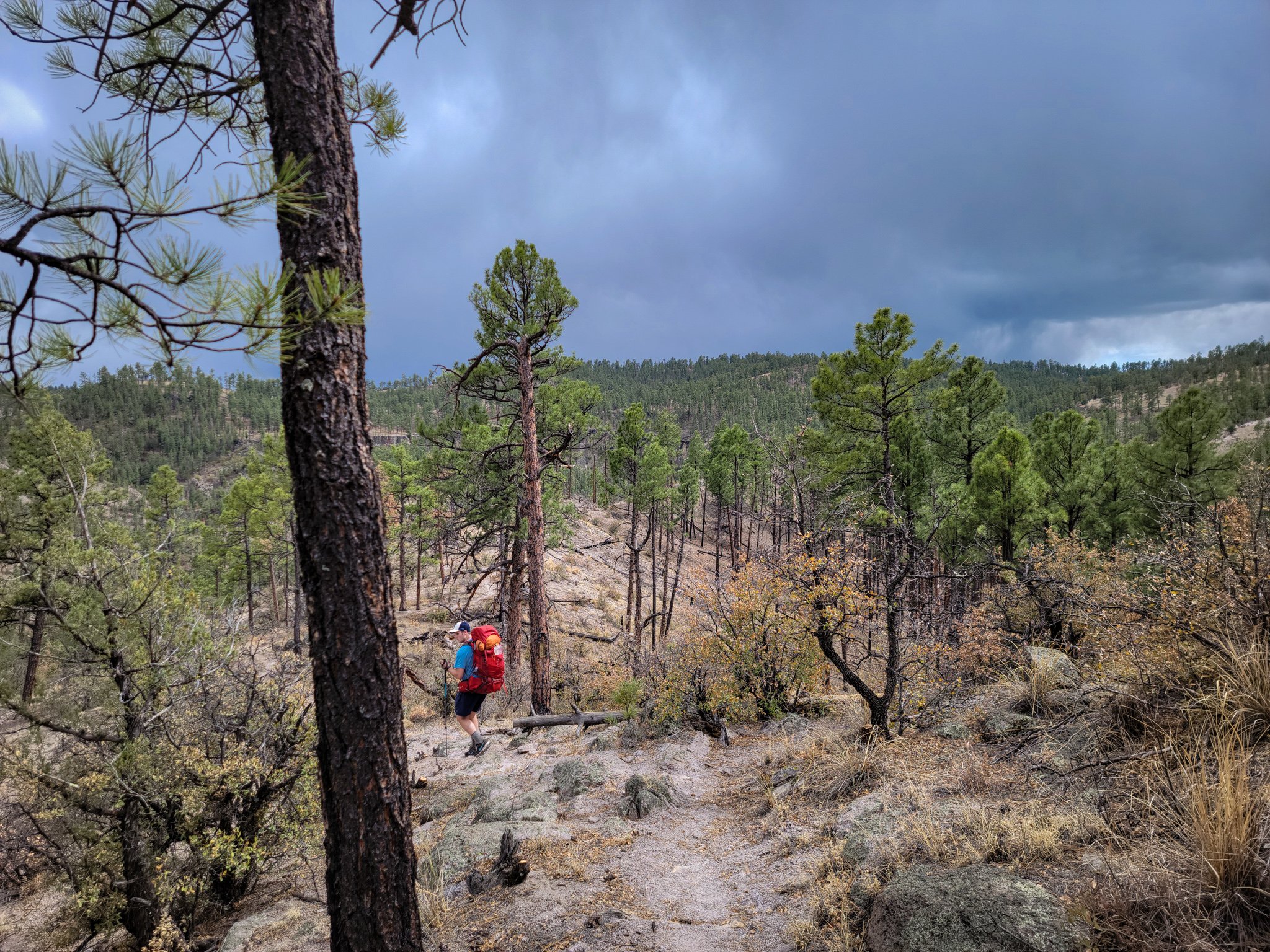
Thanks to the Gaia gpx file, we navigated the different trail junctions to find the crossover towards Prior Cabin where we were hoping to find a spring and camp for the night. The trail slowly wound us up and over the buttes that we had been eyeing from the river. Our packs were heavy with water from the Gila because I knew chances were high that the spring would be dry. Shortly we made it - it felt so different on top than I would have imagined-wide and flat expanses of ponderosa pines greeted us at the top of our late afternoon climb.
Morale was low, but the hiking was flat and breezy from the top of the plateau to the camp, and the pine forest a welcome contrast to the warm canyon below.
We came up to the cabin and immediately saw a couple camped to the west of the structure. They were intently watching us circle around the cabin looking for a campsite and the trail we wanted to continue on. Their gaze wouldn’t let up and it made us more uncomfortable by the second. They may have been just some very bored and curious campers, but their staring felt territorial and urged us to want to camp outside of their unremitting gaze.
We hiked a few more minutes along the trail, looking for a spot on the hills before it plunged down into a small ravine. We were ready to camp, and picked a less than ideal spot on the hill. Luckily the wind wasn’t as fierce and our sites weren’t as slanted as they could’ve been. I set up my camera for a time-lapse and enjoyed a warm dinner. Chatter was minimal and we said goodnight before the sun went gone down. I was beginning to worry that my cousin would never want to backpack again, but I hoped the memories would focus more heavily on the beautiful water and cliff walls rather than how cold that evening was.
Day Three
Still scarred from the late start and slog of yesterday, we both woke up shortly after the sunrise and began packing up. The morning started with pleasant ponderosa flats across the plateau, then a sharp descent down into the West Fork of the Gila, which we had yet to see. Near the descent I found a single red trail runner, the same brand of shoe that I wore, and wondered at how a single shoe had been lost. It made sense that some people switched out their shoes for the river crossings, but that someone wouldn’t be wearing their trail runners and the top of the plateau made no sense to me. I figured no one would be coming back for it, and that many people had already passed this now piece of trash by, so I decided to pack it out. It could’ve been mental, but I felt the weight of this one little red shoe very acutely. It slightly dampened the good mood of the nice morning, my lighter pack from eating a majority of my food, and the excitement of the descent to the river.
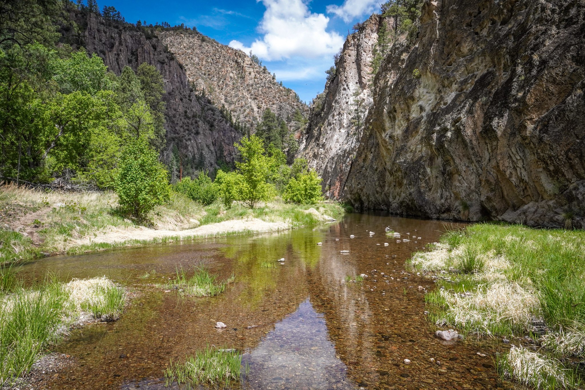
Once we got to the West Fork, my annoyance at the stupid red shoe dissolved. The canyon walls weren’t as tall on this fork, and the rocks had different textures and colors. The river was calm and the infrequent river crossings punctuated lengthy walks through dream-like forests of wildflowers, oaks, pines and of course, more poison ivy.
My legs had continued to burn from the poison ivy and I dreaded the thought of another night trying to find a sleeping position that didn’t hurt my legs. I wasn’t sure if my clothes, sleeping bag and all of my gear was covered in the oil and I would continue to spread it over my body. I was ready to shower, and ready to start the recovery process.
Since we had gotten a good early start, I started considering making it back to the trailhead that evening. We had planned to spend another night out, but by midday we were so close to the trailhead that we would have to either a) slow down and camp pretty soon or b) keep up our pace to get to the car by evening.
Mostly due to the poison ivy, we decided to push to get back to the car that night. I felt bad for making my cousin hike over a 20 mile day on his first backpacking trip, but I knew that he was capable and would at least have a fun story to tell.
We refused to look at our phones or agonize over the miles which definitely helped them go by faster. From one river crossing we were able to see cliff dwellings on the canyon walls facing us. We marveled and my excitement for the national monument on the way out grew (I was less sure how excited my cousin was to add any amount of mileage to our day). As we got closer to the trailhead, the miles felt longer. We were tired, my legs were burning with every step I took, and we were ready to get back to the car.

We knew we were getting close to the trailhead when we saw one couple delicately rock-hopping across the river as we unabashedly plowed through the water for the umpeenth time.
When we finally arrived at the trailhead parking lot, it was strangely quiet for a National Monument. We walked up to a bridge and noticed it was barricaded and the small visitors center was desolate. I found the hours on a sign--they had closed at 4:00pm. We were about an hour too late. I was a little bummed, but figured that this gave more reason to return in the future. The bummers just kept on coming when I realized we still had another mile and a half or so of road-walking to get us to the car. I was worried about breaking this news to Nico, but he took it in stride and after resting on some benches and using the pit toilets in the parking lot, we were on our way.
Back at the car, I immediately washed my legs with soap and water. The soap stung and I screamed as I sudsed up as quickly as I could and rinsed off with a water bottle. It was a crude shower, but it would have to do for the night. We decided to make our way to one of the Forest Service campgrounds and shower and fuel up at Silver City in the morning.
All in all, this was one of the most densely beautiful trips I’ve done. Being so close to water in such a generally dry climate makes for a special trip, with unique plants, animals and scenery on display. I would go back in a heartbeat--just would wear pants and bring poison ivy soap next time!
I hope you’ve enjoyed this trip report! Let me know if you’ve ever been to the Gila or plan on going in the future.